Galilelo – ESA navigation satellite launched
A further step towards the deployment of Europe’s Galileo global navigation satellite system was taken end of April with the successful launch of ESA’s second Galileo In-Orbit Validation Element (GIOVE-B) satellite, carrying the most accurate atomic clock ever flown into space.
Denne artikkelen er tre år eller eldre.
The GIOVE-B satellite was lofted into a medium altitude orbit around the earth by a Soyuz/Fregat rocket departing from the Baikonur cosmodrome in Kazakhstan by launch operator Starsem. Lift-off occurred at 04:16 local time on 27 April (00:16 Central European Summer Time). The Fregat upper stage performed a series of manoeuvres to reach a circular orbit at an altitude of about 23 200 km, inclined at 56 degrees to the Equator, before safely delivering the satellite into orbit some 3 hours and 45 minutes later. The two solar panels that generate electricity to power the spacecraft deployed correctly and were fully operational by 05:28 CEST.
This 500 kg satellite was built by a European industrial team led by Astrium GmbH, with Thales Alenia Space performing integration and testing in Rome. Two years after the highly successful GIOVE-A mission, this latest satellite will continue the demonstration of critical technologies for the navigation payload of future operational Galileo satellites.
Three high-accuracy space clocks aboard
Like its predecessor, GIOVE-B carries two redundant small-size rubidium atomic clocks, each with a stability of 10 nanoseconds per day. But it also features an even more accurate payload: the Passive Hydrogen Maser (PHM), with stability better than 1 nanosecond per day. The first of its kind ever to be launched into space, this is now the most stable clock operating in earth orbit. Two PHMs will be used as primary clocks onboard operational Galileo satellites, with two rubidium clocks serving as back-up.
GIOVE-B also incorporates a radiation-monitoring payload to characterise the space environment at the altitude of the Galileo constellation, as well as a laser retroreflector for high-accuracy laser ranging.
Signal generation units will provide representative Galileo signals on three separate frequencies broadcast via an L-band phase array antenna designed to entirely cover the visible earth below the satellite.
The satellite is now under the control of Telespazio’s spacecraft operations centre in Fucino, Italy, and in-orbit checking-out of the satellite has begun.
Final demonstration before Galileo
In addition to its technology-demonstration mission, GIOVE-B will also take over GIOVE-A’s mission to secure the Galileo frequencies, as that first Galileo demonstration satellite launched in December 2005 is now approaching the end of its operational life.
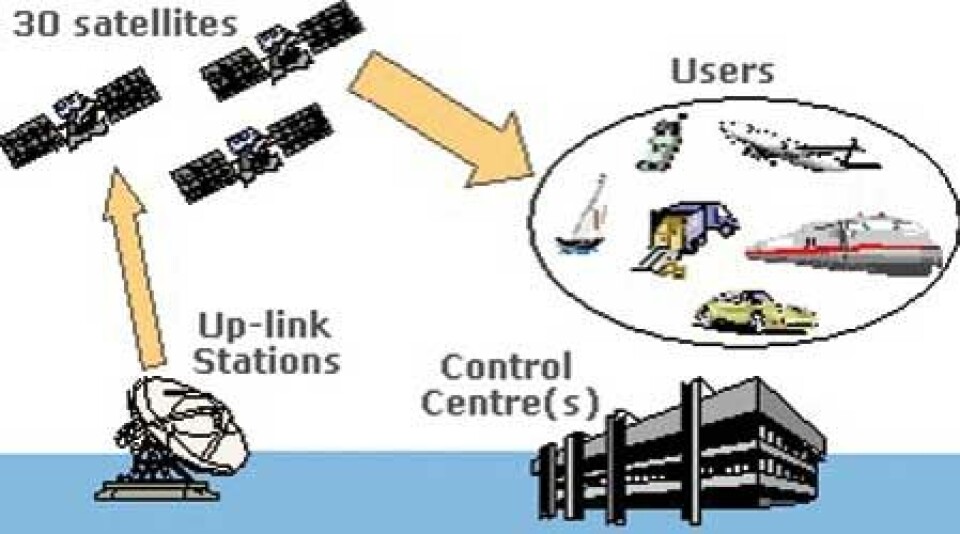
Beyond GIOVE-B, the next step in the Galileo programme will be the launch of four operational satellites, to validate the basic Galileo space and related ground segment, by 2010. Once that In-Orbit Validation (IOV) phase is completed, the remaining satellites will be launched and deployed to reach the Full Operational Capability (FOC), a constellation of 30 identical satellites.
– With the successful launch of GIOVE-B, we are about to complete the demonstration phase for Galileo, said ESA Director General Jean Jacques Dordain in Fucino while congratulating the ESA and industrial teams. – The strong cooperation between ESA and the European Commission has been instrumental in making progress in a difficult environment over the past few years; and, even with that being so, Galileo has already materialised, with two satellites now in orbit, significant headway made on the next four (already in the construction phase) and a fully qualified EGNOS service – all this designed to serve citizens in Europe and all around the globe. ESA will begin shortly the procurement process for the overall constellation beyond IOV under EC responsibility.
GNS
Galileo will be Europe’s very own global navigation satellite system, providing a highly accurate, guaranteed global positioning service under civil control. It will be interoperable with the US Global Positioning System (GPS) and Russia’s GLONASS, the two other global satellite navigation systems. Galileo will deliver real-time positioning accuracy down to the metre range with unrivalled integrity.
Numerous applications are planned for Galileo, including positioning and derived value-added services for transport by road, rail, air and sea, fisheries and agriculture, oil-prospecting, civil protection, building, public works and telecommunications.
It will guarantee availability of the service under all but the most extreme circumstances and will inform users within seconds of a failure of any satellite. This will make it suitable for applications where safety is crucial, such as running trains, guiding cars and landing aircraft.
The fully deployed Galileo system consists of 30 satellites (27 operational + 3 active spares), positioned in three circular Medium Earth Orbit (MEO) planes at 23 222 km altitude above the Earth, and at an inclination of the orbital planes of 56 degrees with reference to the equatorial plane.
Once this is achieved, the Galileo navigation signals will provide good coverage even at latitudes up to 75 degrees north, which corresponds to the North Cape, and beyond. The large number of satellites together with the optimisation of the constellation, and the availability of the three active spare satellites, will ensure that the loss of one satellite has no discernible effect on the user.
Two Galileo Control Centres (GCCs) will be implemented on European ground to provide for the control of the satellites and to perform the navigation mission management. The data provided by a global network of twenty Galileo Sensor Stations (GSSs) will be sent to the Galileo Control Centres through a redundant communications network. The GCC’s will use the data from the Sensor Stations to compute the integrity information and to synchronise the time signal of all satellites with the ground station clocks. The exchange of the data between the Control Centres and the satellites will be performed through up-link stations. Five S-band up-link stations and 10 C-band up-link stations will be installed around the globe for this purpose.
SAR
As a further feature, Galileo will provide a global Search and Rescue (SAR) function, based on the operational COSPAS-SARSAT system. To do so, each satellite will be equipped with a transponder, which is able to transfer the distress signals from the user transmitters to the Rescue Co-ordination Centre, which will then initiate the rescue operation.
At the same time, the system will provide a signal to the user, informing him that his situation has been detected and that help is under way. This latter feature is new and is considered a major upgrade compared to the existing system, which does not provide feedback to the user.
Altogether Galileo will provide five levels of services with guaranteed quality which marks the difference from this first complete civil positioning system.
Who’s involved
Galileo is a joint initiative of the European Commission (EC) and the European Space Agency (ESA).
The EC is responsible for the political dimension and the high-level mission requirements. The EC initiated in particular studies on the overall architecture, the economic benefits and the user needs. These include the GALILEI studies that address the local architectures, interoperability and signals and frequencies. Moreover, they provide a market observatory and cater for investigations into legal, institutional, standardisation, certification and regulatory issues.
ESA’s responsibility covers the definition, development, and in-orbit validation of the space segment and related ground element. Work on the new technologies needed for the satellite constellation and the ground segment has been continuing at ESA’s European Space Research and Technology Centre (ESTEC), at Noordwijk, in the Netherlands for a number of years. These critical technologies include the high precision clocks to be carried on-board the satellites (rubidium and passive hydrogen maser frequency s
tandards), on-board timing units for synchronising the individual clocks to a common Galileo system time, signal generators to produce the positioning signals that the Galileo spacecraft will broadcast, power amplifiers, radio-frequency multiplexers & antennas and telecommand & telemetry transponders.
In parallel, the Galileo System Simulation Facility (GSSF) has been built to test strategies for coping with contingencies when the full system is up and running. In addition, the Galileo Signal Simulation Facility helps with the fine-tuning of the Galileo signal design. ESA has also supported work on technologies needed for Galileo receivers.
The second phase of the GSTB, now named Galileo In-Orbit Validation Element (GIOVE), comprises test satellites whose missions are primarily to check the critical technologies needed for the Galileo system. They will also characterise the medium Earth orbit chosen for the Galileo constellation. Europe has no experience of this environment, since there has never been a European satellite orbiting in this region of near-Earth space.
The Galileo partners include the GNSS Supervisory Authority, which replaced the Galileo Joint Undertaking (GJU) on 1 January 2007. The GJU initiated the development of a full set of applications through calls for ideas in the framework of the European Commission’s research and development programmes. The GJU was also intended to select a Galileo concessionaire within a private-public partnership.


